Tuesday, October 23, 2012
Seven Thevara Stalams (Lord Siva Worship Places) in Kongu Region
The sanctum of this temple bears depictions of the 7 Thevara temples in Kongu Naadu.( sivan temple )
1.Avinashi Temple, Avinashi,Thirupur
This temple is regarded as the first of the seven Thevara Stalams in the Kongu Region of Tamil Nadu
View Larger Map
2. Arthanareeswarar temple Tiruchengode
This temple is regarded as the second of the seven Thevara Stalams in the Kongu Region of Tamil Nadu
View Larger Map
3.Sangameswarar Temple ,Bhavani, Tamil Nadu
This temple is regarded as the 3rd of the 7 Thevara Stalams in the Kongu Region of Tamil Nadu
View Larger Map
4.Sri Kalyana Pasupathinathar Temple,Karur
This temple is regarded as the 4th of the 7 thevara Stalams in the Kongu Region of Tamil Nadu.
Karuvoor Aanilai as Lord Siva in this temple
View Larger Map
5.Tirumuruganathaswamy Temple, Tirumurugapoondi, Avinashi
This temple is regarded as the 5th of the 7 thevara Stalams in the Kongu Region of Tamil Nadu. Lord siva as Muruganathar in this temple
View Larger Map
6. Arulmigu Magudeshwaar , Kodumudi,Erode(Tiruppandikodumudi)
This temple is regarded as the 6th of the 7 thevara Stalams in the Kongu Region of Tamil Nadu. Kodumudinathar as Lord Siva in this temple
View Larger Map
7. Vigirthanatheswarar,Venjamaakudal ,Aravakurichi(tk) ,Karur
This temple is regarded as the 7th of the 7 thevara Stalams in the Kongu Region of Tamil Nadu. Vikriteswarar as Lord Siva in this temple
The Sthala Teertham is Vigirtha teertham. With his pathigams, Saint Sundarar is said to have praised the lord.The temple is located on the east bank of river Kudaganaaru.This shivasthalam is more than 1200 years old
.
View Larger Map
Kangeyam In Kongu Region
Kangeyam (Tamil: காங்கேயம்) is a municipality in Tirupur district in the Indian state of Tamil Nadu. Kangeyam was the capital of Kongu Nadu for many centurie
There is no definite origin for the word Kongu, several scholars have given their views. The name Kongu Nadu is believed to have been gained from 'Kongadesam', "Konga" a derivant of the term "Ganga", meaning 'land of the Gangas' see Western Ganga Dynasty. Kangayam is the old capial of Kongu Nadu, (Sanskrit: Ganga+eyam = Gangeyam : seat of the Western Ganga Dynasty. Kongu means in Sangam Tamil 'border'.A more appropriate meaning is honey or nectar of flowers as the Kongu country had vast stretches of forests
Dharapuram In Kongu Region
Dharapuram (also known as Rajarajapuram by the Tanjore Cholas), is a town and a municipality in theTirupur district of the South Indian state of Tamil Nadu. Dharapuram is one of the oldest towns in Tiruppur District. Dharapuram was the capital of Kongu Nadu under Kongu Cholas, at which time it was known asVanchipuri. The Amaravathi River flows through the city.
Dharapuram was part of the Chera kingdom until 850 A.D. From 1000 A.D. to 1275 A.D., the area was ruled by the Kongu Cholas who renamed Dharapuram Vanchipuri (also Viradapuram). The Cholan capital was under attack by a hitherto unknown group in South India, called Kalabhars, during Tamilakam. As a result, the Kongu Cholas made this their military and political headquarters. The Tanjore Cholas named the cityRajarajapuram. After 1276 A.D. the Pandyan empire took control of the region. The Pandyan ruler Veerapandian made Kongu chieftain Kalingarayar (which translates to "slayer of Kalinga King's head in battlefield"), the Prime minister of the Pandyan empire. During this period, this visionary dug the famous Kalingarayan Channel, which continues to irrigate the region.
The Viradapuram Raja built a fort in the heart of Vanchipuri. The Muslims (Modern Sulthans) ruled next, after which the Nayaks of Madurai ruled. They were followed by Hyder Ali and Tippu Sultan. In 1799, when Tippu fell to the British, the East Indian Company took over administration of this region. The British stationed their military camp in Therupatti on the Palani road, regularly practicing rifle firing in the Kannimar Hills. The ancient foundry of the Chera, Kongu Nadu (Kollan Pattari), is also found in the same village.
Dharapuram and Coimbatore gained the status of Municipality on the same day. Dharapuram Municipality was promoted to first grade municipality on May 6, 1983. Dharapuram Town is situated along 9.62 km2 of the bank of River Amaravathi. Under British control, Dharapuram was the capital of South Noyyal District, and Bhavani was the capital of North Noyyal District. Now Tiruppur district has taken the leadership role
The Viradapuram Raja built a fort in the heart of Vanchipuri. The Muslims (Modern Sulthans) ruled next, after which the Nayaks of Madurai ruled. They were followed by Hyder Ali and Tippu Sultan. In 1799, when Tippu fell to the British, the East Indian Company took over administration of this region. The British stationed their military camp in Therupatti on the Palani road, regularly practicing rifle firing in the Kannimar Hills. The ancient foundry of the Chera, Kongu Nadu (Kollan Pattari), is also found in the same village.
Sunday, October 21, 2012
Pugali Malai, Balasubramaniswamy Temple, Karur(Arunattan Mala)
The beautiful & very old(2500 years) hill temple for lord muruga is here.
It is in Kaveri river bank.
It is in Kaveri river bank.
Velayuthampalayam is a town located in Karur District in the Indian state of Tamil Nadu. It comes under the jurisdiction of Punjai Pugalur Town Panchayat. This town is situated on the footsteps of Arunattan Malai, which houses Lord Muruga. The river Cauvery is 3 kilometers away from the town.It is very close to TNPL Pugalur.


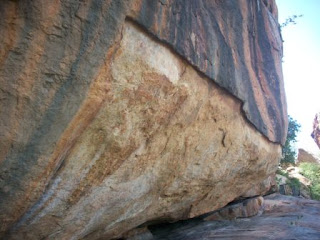
This place is called Velayudhampalayam because of this temple. Lord Muruga has a weapon in his hand always which is called a Vel. Ayudham means weapon. So that is Velayudhampalayam. This place is also called Arnattan Malai, which mean it’s a natural hillock and not man made. This is also manipulated as Arunattan Malai which means the hillock which belongs to the 6 regions i.e this was centrally located to 6 regions. Other names for the place are Pugazhimalai, Pugazhiyur and Pugazhur.
I enquired the priest here about the Tamil Brahmi Script and he said it is locked up and the key is with the security guy who would be at the base of the hillock. Then he also said that the key might be with his bro who was the priest at the nearbyMariamman temple. No other go, I went down to find this security guy who was missing. So I went to the Mariamman Temple
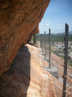
The gate to go to the caves is located near the Idumban Shrine. I was accompanied by the priest of Balasubramaniar Temple
There are actually 2 caves and 4 gates. Heavy security to preserve our heritage!!! Passing through the first 2 gates took me to the first cave where first cave.
Enroute was this interesting tree here from atop which had its roots through the rocks and finally hanging atop my head!!!
Did I tell you these caves also had Jain Beds.? Samana Padukkaigal as it is called in Tamizh, these are flat surfaces chiseled out by the Jain Monks who resided here in the 1st & 2nd C AD. These were flat surfaces sculpted out of the rocks with an elevated portion for the head like a pillow. So creative, isn’t it.? Also are some little ridges carved out. These might have been used to light up lamps with oil and some cotton fabric.
Here was the first set of inscriptions. So brainy they are to create a little ridging of the rock all through its length and then inscribing their wordings. This ridging has helped the inscriptions to survive the harsh rains.
From there the third gate. Now the route is hardly little enough to hold a person. There was the second set of inscriptions.
Sunday, October 14, 2012
Karur In kongu region
Karur was built on the banks of River Amaravathi which was called Aanporunai during the Sangam days. The names of the early Chera kings who ruled from Karur, have been found in the rock inscriptions in Aru Nattar Malai close to Karur. The Tamil epic Silapathikaram mentions that the famous Chera KingSenguttuvan ruled from Karur. In 150 AD Greek scholar Ptolemy mentioned Korevora (Karur) as a very famous inland trading center in Tamil Nadu.
[edit]Rulers of Karur
Karur may have been the center for old jewellery-making and gem setting (with the gold imported mainly from Rome), as seen from various excavations. According to the Hindu mythology, Brahma began the work of creation here, which is referred to as the "place of the sacred cow."
The Pasupatheesvarar Temple sung by Thirugnana Sambhandar, in Karur was built by the Chola kings in the 7th century. Karur is one of the oldest towns in Tamil Nadu and has played a very significant role in the history and culture of the Tamils. Its history dates back over 2000 years, and has been a flourishing trading center even in the early Sangam days. It was ruled by the Cheras, Gangas, Cholas, the Vijayanagara Nayaks, Mysore and the British successively. Epigraphical, numismatic, archaeological and literary evidence have proved beyond doubt that Karur was the capital of early Chera kings of Sangam age. And Kongunadu is only the Chera Kingdom that extended up to the western coast till Muziri in Kerala, South India when the empire was at its peak and which the Cheras made it as their main port city. The Chera Kings and Kongudesa Rajakkal were one and the same. In olden days it was called Karuvoor or Vanchi or Vanji during Sangam days. There has been a plethora of rare findings during the archaeological excavations undertaken in Karur. These include mat-designed pottery, bricks, mud-toys, Roman coins, Chera Coins, Pallava Coins, Roman Amphorae, Rasset coated ware, rare rings, etc.
Karuvoor Thevar born in Karur, is one among the nine devotees who sung the divine Music Thiruvichaippa, which is the ninth Thirumurai. He is the single largest composer among the nine authors of Thiruvichaippa. He lived during the reign of the great Rajaraja Chola-I. In addition to the famous Siva Temple., there is a Vishnu Temple at Thiruvithuvakkodu suburb of Karur, sung by famous Kulasekara Alwar, 7th century AD, who was the ruler of Kongu nadu. The same Temple is presumably mentioned in epic Silappadikaram as Adaha maadam Ranganathar whose blessings Cheran Senguttuvan sought before his north Indian expedition.[1]
Later the Nayakars followed by Tipu Sultan also ruled Karur. The British added Karur to their possessions after destroying the Karur Fort during their war against Tipu Sultan in 1783. There is a memorial at Rayanur near Karur for the warriors who lost their lives in the fight against the British in the Anglo-Mysore Wars. Thereafter Karur became part of British India and was first part of Coimbatore District and later Tiruchirappalli District.
Karur is also a part of Kongu Nadu. The history of Kongu nadu dates back to the 8th century. The name Kongunadu originated from the term "Kongu", meaning nectar or honey. Kongu came to be called as Kongu nadu with the growth of civilization. The ancient Kongunadu country was made up of various districts and taluks which are currently known as Palani, Dharapuram, Karur, Nammakkal, Thiruchengodu, Erode, Salem, Dharmapuri, Satyamangalam, Nilgiris, Avinashi, Coimbatore, Pollachi and Udumalpet.
[edit]Chera Rulers
Karur was ruled by different Chera kings. Kongu Cheras (capital:Karur (Vanji), ruling nearly the whole of old Kongu - lineage unclear- Cheran kootam)
Kodumanal in Kongu Region
Kodumanal was a 2,500-year-old industrial estate discovered in Kongu Nadu. KonguNadu is the most industrialised and prosperous region in Tamil Nadu.
Kodumanal is a village located in the Erode district in the southern Indian state of Tamil Nadu. It was once a flourishing ancient trade city known as Kodumanam, as inscribed in Patittrupathu of Sangam Literature.The place is a important Archaeological Site, under the control of State Archaeological Department of Tamil Nadu. It is Located on the northern banks of Noyyal River, a tributary of the Cauvery.
The city played a major role in Indo-Roman trade and relations, as the ancient city is located on the mid-way of a Roman Trade Route, linking Muziris Port i.e. Pattanam on the Malabar Coast with the Kaveripoompattinam (Puhar) Port in the Coromandel Coas.
Kodumanal, celebrated in Tamil Sangam literature (datable from the second century BCE to the second century C.E.), is now one of the most explored sites in India. The Sangam work Pathitruppatthu refers to Kodumanal as Kodumanam in two places. While the poet Kabilar refers to it as “Kodumanam patta… nankalam”, another poet, Arisil Kizhar, celebrates it as “Kodumanam patta vinaimaan arunkalam”, that is, Kodumanam, the place where rare jewels are made. A horizontally excavated site, Kodumanal has yielded the highest number of inscribed potsherds (about 315 potsherds with Tamil-Brahmi inscriptions) and also the largest number of exposed graves for any single archaeological site in India.
http://www.hindu.com/thehindu/thscrip/print.pl?file=20120810291506200.htm&date=fl2915/&prd=fline&
Tuesday, October 2, 2012
Kongu Vellalar Survey
Hi , Please Take a survey
click on Kongu Vellalar Survey
Please click above link & submit your temple details if your temple not listed
Subscribe to:
Posts (Atom)